The Stakes
The race for compliance is upon us. As the European Union Deforestation Regulation (EUDR) December 30th deadline approaches, companies are facing the challenges of what it means to be deforestation-free in EU markets. This new mandate requires commodities like cocoa, coffee, soy, palm oil, cattle, wood, and rubber to be legally produced and originate from land that has not been subject to deforestation or forest degradation since December 31, 2020.
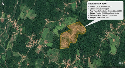
Most importantly, companies must declare the individual plots of land that these commodities originate from, in order to continue shipping these commodities and their derivatives into the EU. Our estimates put the number of plots globally producing EUDR commodities at roughly 64M. This means that before December 31, 2026, roughly 64 million plots need to be mapped to be declared in the due-diligence statements for EUDR. This has created the single biggest bottleneck in EUDR implementation for most companies.
Hitting the Data Wall
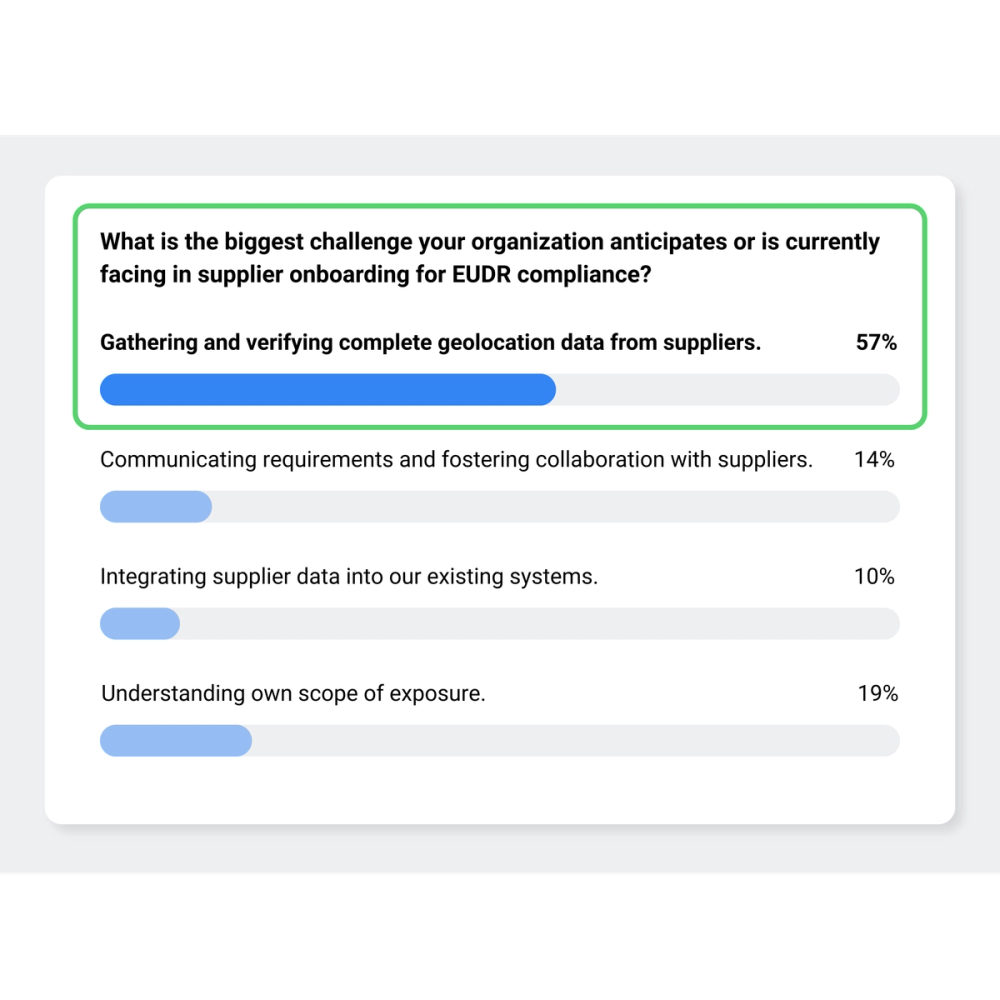
Recent industry polls have identified the gathering and verification of complete geolocation data as the single biggest issue companies face in attempts to achieve EUDR compliance. Despite years of preparation, many organizations are running headfirst into a data wall. While direct "Tier 1" suppliers are typically willing and able to cooperate with new requirements, the "Tier N" suppliers (the network of millions of smallholders and indirect farmers)are often fundamentally unable to provide the necessary data. This reality check will take a massive toll across industries if companies cannot connect their supply chain down to the plot level.
Why Geolocation Data is Failing
Relying on traditional methods to gather manually mapped polygon data is creating clear friction points on the path to meeting EUDR mandates. This is because of some structural issues that are unlikely to be resolved in the foreseeable future:
- Sovereignty & Legal Barriers: Many producer countries have strict laws that restrict or outright prevent the sharing of farm-level geolocation data outside their borders, creating a severe legal deadlock for EU importers.
- The Cost of "Ground Truth": Deploying personnel to manually walk and map the perimeters of every farm is prohibitively expensive and incredibly time consuming. Mapping a complex, multi-tiered supply base with traditional methods can take years—time the EUDR clock does not have.
- Accuracy Concerns: Data collected on the ground, especially in smallholder contexts, is often riddled with human errors. Even a single "shifted" coordinate can falsely flag a compliant farm as a deforestation risk.
- The "Obsolete Data" Trap: Agricultural landscapes are fluid. Farm boundaries expand, contract, and sourcing locations can change. A boundary map collected two years ago may already be obsolete by the time the latest shipment hits an EU port. This is especially important as these ground data collection exercises can take years to complete; and by the time they are finished, the data is already outdated, because the sourcing farms may have changed or the boundaries may have shifted.
Epoch Is Automating the "Un-mappable"
It is time to shift the paradigm. Instead of waiting for suppliers to send data that might never arrive, companies can now take ownership of their EUDR compliance.
Epoch removes the initial dependency on the supplier to produce a map by leveraging advanced AI to automatically generate highly accurate field boundaries globally, even deep within fragmented smallholder landscapes. This allows companies to mass-screen thousands of suppliers simultaneously, providing an instant, bird’s-eye view of your entire supply base while evaluating millions of hectares for deforestation risks and environmental metrics.
Using these automated results, you can immediately triage your supply chain to separate low-risk from high-risk suppliers. For those suppliers that have non-compliant plots, a targeted engagement with exact locations of non-compliant plots can resolve issues in an efficient and collaborative way. Instead of every single supplier for manual data, your teams can focus their resources on effectively engaging only the suppliers located in non-compliant hotspots for necessary remediation and verification.
From Reactive to Proactive
Geospatial technology has moved faster than the regulation itself. You no longer need a manual surveyor on every single farm to prove your products are deforestation-free. Don’t gamble with your market access while waiting for supplier provided data.
Take control of your compliance today. Contact Epoch for a demo on how to map your "invisible" supply chain and secure your EUDR readiness.